Jennifer Henning's Genealogy Site
Jennifer Henning
Sant' Elia
Palermo Province, Sicily
Related Families in Sant' Elia
Navigation
Copyright ©2005-2021 byThis page created January 16th, 2018, last updated January 26th, 2021
Palermo Province, Sicily

| |
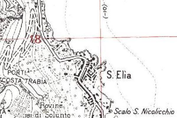
| To zoom out to a larger area map click here. | |
|---|---|
The map covers an area of approximately 1.5 by 1.0 km (0.9 by 0.6 US miles).
Map image was adapted from Cartografia di base IGM 25.000 - Regioni zona WGS84
The following table shows which of the individuals included in this web site are connected to Sant' Elia and over what time span they are found here.
| Surname | Given names and the range of dates the person was found in Sant' Elia |
|---|---|
| Alioto |
 Giuseppe 1872 Giuseppe 1872 Rosa 1883 Rosa 1883 Stefana 1802..1887 Stefana 1802..1887 |
| Balistrieri / Balestreri / etc |
 Andrea 1863..1898 Andrea 1863..1898 Anna 1912 Anna 1912 Anna 1905 Anna 1905 Antonina 1897 Antonina 1897 Antonino 1883 Antonino 1883 Antonino 1900 Antonino 1900 Antonino 1902 Antonino 1902 Aurelia 1892 Aurelia 1892 Caterina 1825 Caterina 1825 Caterina 1887 Caterina 1887 Francesca 1895 Francesca 1895 Francesco 1877 Francesco 1877 Francesco 1909 Francesco 1909 Francesco 1840..1861 Francesco 1840..1861 Gaetano 1787..1843 Gaetano 1787..1843 Gaetano 1696..1764 Gaetano 1696..1764 Gaetano 1856..1899 Gaetano 1856..1899 Gaetano 1898 Gaetano 1898 Gaetano 1861..1943 Gaetano 1861..1943 Giuseppa 1889 Giuseppa 1889 Giuseppe 1871 Giuseppe 1871 Giuseppe 1888 Giuseppe 1888 Giuseppe 1898 Giuseppe 1898 Giuseppe 1898 Giuseppe 1898 Giuseppe Francesco Paolo Isidoro 1762..1809 Giuseppe Francesco Paolo Isidoro 1762..1809 Giuseppi Tommaso 1825..1887 Giuseppi Tommaso 1825..1887 Giuseppina 1890 Giuseppina 1890 Leonora 1820..1865 Leonora 1820..1865 Maria 1899 Maria 1899 Pietro 1874..1912 Pietro 1874..1912 Pietro 1843 Pietro 1843 Rosa 1882 Rosa 1882 Rosa 1859..1870 Rosa 1859..1870 Rosa 1870..1946 Rosa 1870..1946 Rosa 1900 Rosa 1900 Stefana 1885 Stefana 1885 Stefana 1852..1875 Stefana 1852..1875 Vito 1891 Vito 1891 |
| Bellanti |
 Anna 1897 Anna 1897 Anna 1898 Anna 1898 Giovanni 1908 Giovanni 1908 Giuseppe S. 1910 Giuseppe S. 1910 Maria 1900 Maria 1900 Rosa 1904 Rosa 1904 Tommaso 1912 Tommaso 1912 |
| Billante |
 Caterina 1872..1875 Caterina 1872..1875 Domenico 1830..1883 Domenico 1830..1883 Eleanora 1880 Eleanora 1880 Giovanni 1866..1897 Giovanni 1866..1897 Maria 1875..1883 Maria 1875..1883 Maria 1883..1912 Maria 1883..1912 Pietro 1861..1866 Pietro 1861..1866 Pietro 1869..1912 Pietro 1869..1912 Rosa 1864..1885 Rosa 1864..1885 Rosalia 1878..1949 Rosalia 1878..1949 |
| Busalacchi |
 Antonino 1845..1876 Antonino 1845..1876 Francine 1896 Francine 1896 Giovanna 1877..1897 Giovanna 1877..1897 Maria Pietra 1870..1898 Maria Pietra 1870..1898 Pietro 1891 Pietro 1891 Pietro 1843..1924 Pietro 1843..1924 Rosa 1805 Rosa 1805 Vito 1837 Vito 1837 |
| D'amico |
 Giuseppe 1877 Giuseppe 1877 |
| Defazio |
 Delibria 1848 Delibria 1848 |
| Deluca |
 Antonina 1854..1899 Antonina 1854..1899 Antonino 1739..1782 Antonino 1739..1782 Caterina 1772..1837 Caterina 1772..1837 Giovanni Battista 1882 Giovanni Battista 1882 Salvadore 1852 Salvadore 1852 |
| Dentici |
 Anna 1841..1916 Anna 1841..1916 Anna 1843..1932 Anna 1843..1932 Antonina 1852..1949 Antonina 1852..1949 Calogero 1840 Calogero 1840 Calogero 1846..1892 Calogero 1846..1892 Gaetano 1844 Gaetano 1844 Giuseppe 1865..1869 Giuseppe 1865..1869 Pietro 1811..1868 Pietro 1811..1868 Salvatore 1858 Salvatore 1858 Stefana 1849 Stefana 1849 |
| Galioto |
 Francesco Salvatore 1898 Francesco Salvatore 1898 Rosa 1851 Rosa 1851 |
| Machi |
 Andrea 1795..1885 Andrea 1795..1885 Gaetano 1825..1874 Gaetano 1825..1874 Joseph 1896 Joseph 1896 Pietro 1862..1890 Pietro 1862..1890 Rosa 1896 Rosa 1896 Rosa 1852..1885 Rosa 1852..1885 |
| Pagano |
 Angela Margherita 1762 Angela Margherita 1762 |
| Tarantino |
 Antonia 1725..1782 Antonia 1725..1782 Carmelo 1886 Carmelo 1886 Providenza 1875..1912 Providenza 1875..1912 Rosa 1833..1874 Rosa 1833..1874 Vincenzia Francesca 1889 Vincenzia Francesca 1889 |
| Vella |
 Onofrio 1890 Onofrio 1890 |