Jennifer Henning's German Genealogy Site

Let me know if we are researching the same people or places.


Name and place indexes for this entire web site.

Information on just this family and region.

Introduction to this web site.
Copyright ©2005-2018 by Jennifer Henning
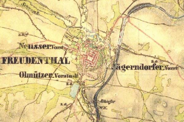
Freudenthal
(now Bruntal)
Kreis Troppau, Austrian Silesia
Related Families in Freudenthal
Navigation
Let me know if we are researching the same people or places.
Name and place indexes for this entire web site.
Information on just this family and region.
Introduction to this web site.
This page created August 26th, 2012, updated October 14th, 2016, last edited January 21st, 2018
Kreis Troppau, Austrian Silesia
| |
| To zoom out to a larger area map click here. | |
|---|---|
Map dates from ca 1766. It covers an area of approximately 2.2 by 1.5 km (1.4 by 0.9 US miles).
Map image was adapted from 1st Military Survey of Austria, Silsia section 22
The following table shows which of the individuals included in this web site are connected to Freudenthal and over what time span they are found here.
| Surname | Given names and the range of dates the person was found in Freudenthal |
|---|---|
| Naümar |
 Rosina 1683..1704 Rosina 1683..1704 |
| Thiel |
Heinrich 1683 |
| Walter / Walther |
 Anna Rosina 1691 Anna Rosina 1691 Baltzer 1673 Baltzer 1673 Hannß 1683..1690Hans Friedrich 1691Lorentz 1673Maria Elisabeth 1691Meligior 1683 Hannß 1683..1690Hans Friedrich 1691Lorentz 1673Maria Elisabeth 1691Meligior 1683 |
| Wayland |
Marina 1683 |